Local Product Content Development Element Implemented within the Framework of the CROSSDEST SIHU00138 Project
As part of the project, the Hévíz tourism organization collects products from local producers in the region and "tells the story" of each producer and product involved in the program – for example, their connection to geological features, links to local agricultural traditions, and the specific characteristics of raw material use.
As a member of the Bakony–Balaton UNESCO Global Geopark, the project simultaneously presents activities rooted in the local cultural landscape, the people and communities who carry forward its values, and the relationship between products, nature, and geological heritage.
Within the framework of the Hévíz Picnic program, the project uniquely showcases the distinctiveness of the "Hévíz story" through products and producers grounded in geological and natural values.
The Hévíz Picnic Box is available at the Hévíz Tourinform office! The Hévíz Picnic Box is available in 2 sizes: the basic package contains 4 products for 7,500 HUF and the premium package contains 6 products for 10,000 HUF.


Geological aspects
As we introduce the dedicated producers of this region, we invite you to reflect on the fundamental natural forces and processes that have made human society possible — and, in turn, have made the work of these producers possible as well.
Alongside climate and the evolving web of life, one such force is the vast, ever-changing mass of rock beneath our feet.
The environment in which these passionate local producers grow their healthy and flavorful goods has emerged from what we often refer to as the "inanimate world" — a realm that, on a different timescale, is remarkably dynamic.
The fertile soil that nurtures our plants — and ultimately feeds animals and humans alike — exists thanks to geological formations that originated, in some cases, hundreds of millions of years ago under conditions dramatically different from those of today.
Some were formed in warm, tropical seas reminiscent of the Caribbean, others under the icy winds of a climate more typical of Siberia.
We invite you on a journey that spans millions of years — through vanished landscapes whose legacy still shapes the land we call home.
This country may be small, but it holds remarkable geological diversity. Even neighboring villages can differ significantly in their natural features. Geology, however, sees things differently.
From a geological perspective, the land beneath our feet is shaped by recurring "mosaics" of rock — recognizable patterns of a finite set of rock types. That’s why we’ve grouped the geological environments of the producers into distinct categories.
Much of this region lies within the Bakony–Balaton UNESCO Global Geopark, a landscape of extraordinary geological variety by international standards.
To learn more about the geopark, visit:
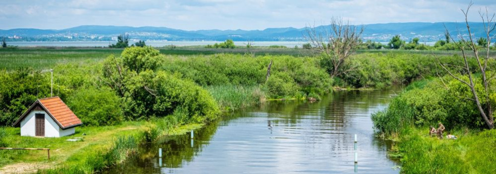
Did you know the Zala River once flowed into the Drava and only later “found” Lake Balaton?
The history of western Hungary’s water systems is not just a fascinating geological puzzle — it reads like an epic of Earth history: riverbeds shift, rivers “consume” one another, and even Lake Balaton doesn’t enter the scene until the final chapter. Discover how nature reshaped this landscape stroke by stroke — and how the Zala became Balaton’s most vital source of water.
The Quaternary Period and the Power of Landscape Formation
What sets the Quaternary Period (2.58 million years ago to the present) apart from earlier geological epochs is that the surface-shaping processes of this time — and the landforms they produced — continue to define our geographic environment today.
Pleistocene Changes: Riverbed Migrations and Terraces
One of the most pivotal surface processes during the Pleistocene (2.58 to 0.01 million years ago) was the migration of riverbeds and the formation of terraces and alluvial fans. These changes were closely tied to the slow retreat of the Pannonian Lake, which once filled much of the Carpathian Basin (see also: The Legacy of the Ancient Pannonian Lake).
The Ancient Danube Moves West
The early Danube initially flowed westward across what is now western Hungary, draining into the retreating Pannonian Lake. This westward course likely remained until the early Pleistocene.
A River’s Great Turning Point
The most dramatic hydrological change in the Carpathian Basin occurred between the Pliocene and Pleistocene: the formation of the Danube’s Visegrád Gorge (today’s Danube Bend), which diverted the river toward the center of the country and what is now the Pest Plain.
This shift profoundly affected all its former western tributaries — including the Zala.
The Story of the Zala: Migration and Capture
The river system of Central Transdanubia evolved in surprising ways, and the Zala’s journey is one of its most remarkable chapters. The Rába River already flowed northeastward toward the Little Hungarian Plain. The ancient Marcal, running northward, flowed into the Rába — and into it, in turn, flowed the ancient Zala.
But nature redrew the map — using the Zala as its brush. A now-vanished river flowing from north to south (its remnants visible today between Zalaszentgrót and Zalavár) cut into the landscape through a process called headward erosion — where rivers erode backward into the terrain, much like a hot knife slicing through butter. Eventually, it cut into the ancient Zala’s valley and “captured” the river, diverting it into its own course.
A New Path — and the Birth of Lake Balaton
From then on, the Zala made a sharp turn south at Türje and — with no Lake Balaton yet in existence — initially emptied into the Drava. Later, as the depression that would one day become Lake Balaton deepened, the Zala was gradually drawn toward it.
Lake Balaton, as a continuous body of water, is only about 5,000 years old — but for millions of years before, the Zala had already been on a winding journey that ultimately made it Balaton’s primary source of water, and the most life-giving river in the region today.
The Life-Giving Winds of the Ice Age: How Loess Shaped the Land
Did you know that Transdanubia’s rich, golden soils are actually a gift from the winds of the Ice Age? Loess isn’t just a dry geological term — it’s an ancient natural recipe that gave rise to some of the most fertile soils in the Carpathian Basin. Where vineyards grow today and birds nest in loess cliffs, strong winds once carried yellow dust across the landscape — for thousands of years. Learn how this unique sediment shaped the land and why loess is still essential for sustainable farming today.
What Is Loess and How Did It Form?
The term loess comes from the German word lose, meaning "loose." Loess is a fine-grained, yellowish sediment that was deposited during the Pleistocene epoch (2.58–0.01 million years ago), particularly during glacial periods. It formed in periglacial environments south of the great Scandinavian ice sheet — cold, dry landscapes with little or no vegetation.
The dust was carried by strong Ice Age winds from floodplains and barren steppes, and slowly accumulated over tens of thousands of years. Eventually, calcium carbonate cemented these layers into loess, which developed characteristic vertical fissures.
It’s important to note that the Pleistocene wasn't a single “Ice Age,” but a period that included alternating cold and warm phases — some even warmer than today.
Loess and the Landscape
Loess gave the Carpathian Basin — especially Transdanubia — its distinct terrain.
Steep loess cliffs (sometimes up to 10 meters high), caves that provide nesting sites for bee-eaters and sand martins, centuries-old sunken roads carved into hillsides, and exposed root systems are all part of the landscape’s geological legacy.
Together, they define the unique character of this region — shaped by time, wind, and stone.
Fertility and Water Retention
Loess-rich areas have produced some of the most fertile soils in the region. Many local producers farm on land that sits atop loess. This creates an excellent foundation for agriculture — not just because of the high humus content, but also because loess has outstanding water-holding capacity. Its vertical pores allow moisture to penetrate deeply and remain in the soil, even during dry periods.
A Modern Echo — Dust from the Sahara
Interestingly, the fine Saharan dust that now reaches Central Europe more frequently can be seen as a modern counterpart to loess-forming material. It’s a reminder that the powerful natural forces that shaped the land long ago are still at work today — just on a different scale.
Imagine a vast body of water — over 1,000 meters deep and more than 400 times the size of Lake Balaton — once rippling across this land. The story of the Pannonian Lake is not just a fascinating chapter of geological history, but a legacy that continues to shape the region: it left behind mineral resources, fertile soils, and even inspired legends. Discover how an ancient lake transformed Transdanubia — and why its impact is still felt today.
An Inland Sea for Millions of Years
At its greatest extent, the Pannonian Lake covered an enormous area, far surpassing the size of today’s Balaton. For millions of years (approximately 12 to 8.5 million years ago), it dominated the region. As surrounding mountain ranges gradually rose, the lake became cut off from the world’s oceans. Its water slowly turned fresh, and its basin began to fill with sediments. Because of its isolation, the lake developed a unique ecosystem with many endemic species.
The Lake Didn’t Appear Overnight
The Pannonian Lake didn’t simply “appear” in the Carpathian Basin. Its formation was the result of millions of years of tectonic activity and shifting climate. It emerged as an independent, enclosed body of water — no longer connected to the open seas.
Deep Waters, Varied Shores
In some areas, the lake reached depths of over 1,000 meters. Elsewhere, shallower zones supported lagoons, river deltas, and small, isolated lakes. During high water periods, rocky shorelines formed along the mountain fringes — traces of which can still be found today in the Keszthely Hills and the Mecsek Mountains.
The Lake’s Retreat — and Sediment Legacy
Despite its size, the lake was eventually filled in by immense volumes of sediment, carried mainly by rivers flowing from the Alps and the Carpathians. Over the course of 6.5 million years, it gradually disappeared from the landscape.
What did it leave behind?
Its sediments — composed mostly of sand, clay, and fine silt — became the so-called “Pannonian formations,” which today hold key mineral resources (such as petroleum) and aquifers. These formations define much of the surface geology of Transdanubia, including the Zala Hills.
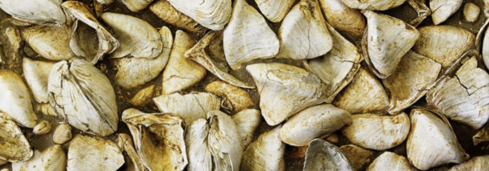
Fertile soils later formed on the laminated silty and clay-rich deposits of the Somló Formation. Even the legendary “Tihany goat’s hoof” fossils — actually worn shell fragments of the Congeria ungulacaprae mollusk — can still be found embedded in these ancient layers.
The Final Lakes and a Gradual Goodbye
Because most of the sediment entered from the northwest, north, and northeast, the lake slowly retreated toward the south and southeast — as if it were “withdrawing” from what is now Hungary.
Small remnant lakes persisted for much longer in areas of present-day Slavonia (Croatia) and northern Serbia, but due to their different scale, character, and fauna, they are not considered true successors of the ancient Pannonian Lake.
About 10,000 years ago, rapid climate warming triggered a cascade of natural responses: torrential floods, landslides, and intense rock weathering. The landscape we walk on today was not shaped over mere centuries, but by the dramatic forces of climate and water, working together. Did you know that the Zala Valley floor is made up of sediments deposited by a kind of "river of time"? Discover how the Earth’s surface became one of the most sensitive indicators of climate change.
Climate Change: Not Just a Modern Phenomenon
We often associate climate change with contemporary issues, but Earth’s climate has shifted many times throughout its history — sometimes quite rapidly. Within large-scale climatic cycles, alternating periods of warming and cooling have long been part of the planet’s natural rhythm.
When Climate Changes, Everything Reacts
A change in climate sets off a chain reaction of environmental processes. It’s not just animals and plants that respond — so does the landscape itself.
Around 10,000 years ago, as the climate warmed significantly, rainfall became more intense.
More rain meant more erosion: stormwater began washing away sediment from hills and valleys into riverbeds. The rivers, now carrying more water and more sediment, flooded more often and spread these materials across the landscape.
Shaping the Terrain
This had a major impact on topography: the land surface became more fragmented and dynamic. Warming temperatures also sped up chemical and physical weathering, breaking down bedrock and helping fertile soil layers to develop.
In short, natural geological processes that had long been underway suddenly accelerated — and reshaped the surface of the land.
Young Sediments at the Base of the Slopes
Today, in many areas of the region, the lower slopes and valley edges are coated with sediment — debris washed down from higher ground, largely within the last 10,000–20,000 years. In the Zala Valley, for instance, these deposits have spread so far that they now reach the center of the valley floor.
The original bedrock source of these sediments varies: in Zala, it’s typically Pannonian sand (Somló Formation), while in the Keszthely Hills, marine-origin carbonates dominate — mostly dolomite, with some limestone. These sediments now appear as fine gravel, pebbles, or coarse sand, quietly recording the environmental changes of the recent past.
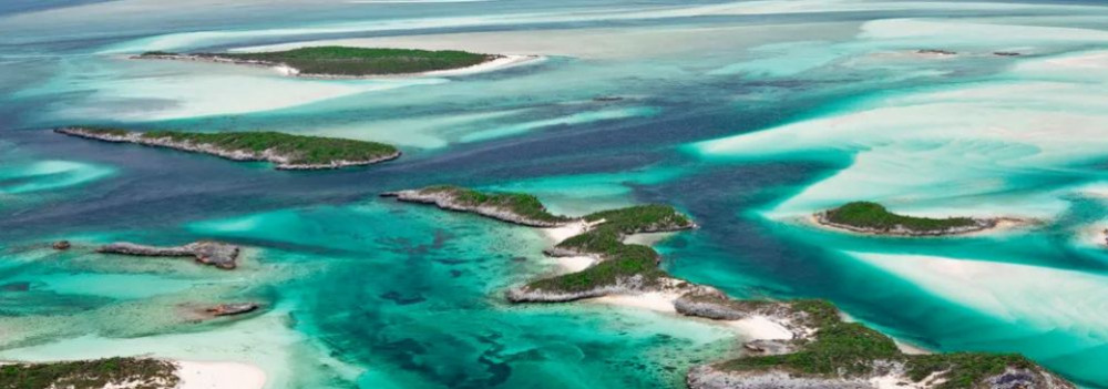
Imagine a tropical sea where the dolomitic peaks of the Keszthely Hills now rise. The landscapes we consider timeless are, in fact, fleeting guests on Earth’s ever-changing stage. How does a shallow tropical sea become Hungarian highlands? Why does dolomite crack? And how does this still influence local farming today? Travel back millions of years into a story written in stone.
The Surface: Only Seemingly Permanent
Mountains, plains, islands, seas, rivers, and lakes may appear permanent within a human lifetime — but from Earth’s perspective, they are only temporary scenes. The rocks that form our planet’s surface are constantly in motion. Like the shattered shell of a boiled egg, tectonic plates drift endlessly atop the semi-fluid mantle beneath them.
Some crash together or sink beneath one another to create towering mountain ranges, while others subside, forming deep trenches or basins that may fill with water. That’s how the dolomite and limestone now forming the Keszthely Hills were once deposited — in the shallow waters of an ancient tropical sea, thousands of kilometers from their present location and long since gone.
The scene would have resembled the crystal-clear shallows of today’s Bahamian paradise.
Volcanoes in the North, a Tropical Sea to the South
While the northern block of the Keszthely Hills is made of relatively young (a few million years old) volcanic rock, the southern section — including Rezi and Cserszegtomaj — is dominated by much older dolomite, formed in those ancient tropical seas. Alongside widespread formations of so-called Main Dolomite, small patches of Rezi Dolomite can also be found — dating back over 200 million years.
The Keszthely Plateau is dissected by a north–south valley system and crisscrossed by micro-tectonic fault lines. Due to the shallow topsoil and varied terrain, more than 70% of the area is forested. Its karst surface experiences year-round water scarcity and has unique ecological features.
The plateau is divided by intermontane basins and bordered by deep tectonic fractures (such as the Hévíz and Ederics faults), making the area seismically sensitive.
Geology and Today’s Land Use
Soils formed on the debris of weathered dolomite provide the natural foundation for land use in the region. Several of our local producers cultivate land along the western edge of the Keszthely Plateau, where farming is defined by the proximity of a highland landscape — a plateau formed of horsts rising 350–440 meters, framed by tectonic fault lines.