Search
Kizárt szavak
Tiltott szavak
- cialis
- viagra
- php
- sql
- html
- https
- http
- chr
- script
- sex
- porn
- sexmassage
Alternatív kifejezések
- =
41. Csizmás Syrup
Last modification: 2025. November. 26. 09:42
The unique highlight of Csizmás Syrup is their lightly herbal syrup made from homegrown hemp, but their raspberry, strawberry, and sour cherry syrups are also well worth a taste.
Találati relevancia adatok
Tárolt adatok:
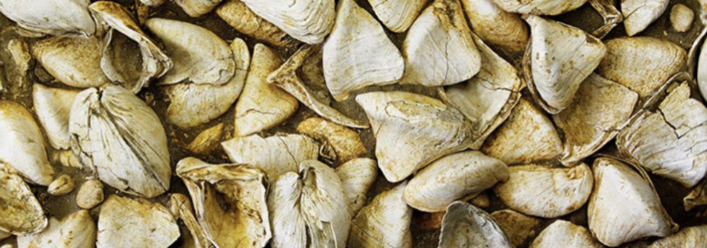
Imagine a vast body of water — over 1,000 meters deep and more than 400 times the size of Lake Balaton — once rippling across this land. The story of the Pannonian Lake is not just a fascinating chapter of geological history, but a legacy that continues to shape the region: it left behind mineral resources, fertile soils, and even inspired legends. Discover how an ancient lake transformed Transdanubia — and why its impact is still felt today.
An Inland Sea for Millions of Years
At its greatest extent, the Pannonian Lake covered an enormous area, far surpassing the size of today’s Balaton. For millions of years (approximately 12 to 8.5 million years ago), it dominated the region. As surrounding mountain ranges gradually rose, the lake became cut off from the world’s oceans. Its water slowly turned fresh, and its basin began to fill with sediments. Because of its isolation, the lake developed a unique ecosystem with many endemic species.
The Lake Didn’t Appear Overnight
The Pannonian Lake didn’t simply “appear” in the Carpathian Basin. Its formation was the result of millions of years of tectonic activity and shifting climate. It emerged as an independent, enclosed body of water — no longer connected to the open seas.
Deep Waters, Varied Shores
In some areas, the lake reached depths of over 1,000 meters. Elsewhere, shallower zones supported lagoons, river deltas, and small, isolated lakes. During high water periods, rocky shorelines formed along the mountain fringes — traces of which can still be found today in the Keszthely Hills and the Mecsek Mountains.
The Lake’s Retreat — and Sediment Legacy
Despite its size, the lake was eventually filled in by immense volumes of sediment, carried mainly by rivers flowing from the Alps and the Carpathians. Over the course of 6.5 million years, it gradually disappeared from the landscape.
What did it leave behind?
Its sediments — composed mostly of sand, clay, and fine silt — became the so-called “Pannonian formations,” which today hold key mineral resources (such as petroleum) and aquifers. These formations define much of the surface geology of Transdanubia, including the Zala Hills.
Fertile soils later formed on the laminated silty and clay-rich deposits of the Somló Formation. Even the legendary “Tihany goat’s hoof” fossils — actually worn shell fragments of the Congeria ungulacaprae mollusk — can still be found embedded in these ancient layers.
The Final Lakes and a Gradual Goodbye
Because most of the sediment entered from the northwest, north, and northeast, the lake slowly retreated toward the south and southeast — as if it were “withdrawing” from what is now Hungary.
Small remnant lakes persisted for much longer in areas of present-day Slavonia (Croatia) and northern Serbia, but due to their different scale, character, and fauna, they are not considered true successors of the ancient Pannonian Lake.
42. Dédi nyomában Biogarden
Last modification: 2025. November. 26. 09:43
Homemade delicacies made from sun-ripened, chemical-free vegetables — straight from the pantry.
Találati relevancia adatok
Tárolt adatok:
About 10,000 years ago, rapid climate warming triggered a cascade of natural responses: torrential floods, landslides, and intense rock weathering. The landscape we walk on today was not shaped over mere centuries, but by the dramatic forces of climate and water, working together. Did you know that the Zala Valley floor is made up of sediments deposited by a kind of "river of time"? Discover how the Earth’s surface became one of the most sensitive indicators of climate change.
Climate Change: Not Just a Modern Phenomenon
We often associate climate change with contemporary issues, but Earth’s climate has shifted many times throughout its history — sometimes quite rapidly. Within large-scale climatic cycles, alternating periods of warming and cooling have long been part of the planet’s natural rhythm.
When Climate Changes, Everything Reacts
A change in climate sets off a chain reaction of environmental processes. It’s not just animals and plants that respond — so does the landscape itself.
Around 10,000 years ago, as the climate warmed significantly, rainfall became more intense.
More rain meant more erosion: stormwater began washing away sediment from hills and valleys into riverbeds. The rivers, now carrying more water and more sediment, flooded more often and spread these materials across the landscape.
Shaping the Terrain
This had a major impact on topography: the land surface became more fragmented and dynamic. Warming temperatures also sped up chemical and physical weathering, breaking down bedrock and helping fertile soil layers to develop.
In short, natural geological processes that had long been underway suddenly accelerated — and reshaped the surface of the land.
Young Sediments at the Base of the Slopes
Today, in many areas of the region, the lower slopes and valley edges are coated with sediment — debris washed down from higher ground, largely within the last 10,000–20,000 years. In the Zala Valley, for instance, these deposits have spread so far that they now reach the center of the valley floor.
The original bedrock source of these sediments varies: in Zala, it’s typically Pannonian sand (Somló Formation), while in the Keszthely Hills, marine-origin carbonates dominate — mostly dolomite, with some limestone. These sediments now appear as fine gravel, pebbles, or coarse sand, quietly recording the environmental changes of the recent past.
43. Emese Cheese Workshop
Last modification: 2025. November. 26. 09:45
High-quality, artisanal goat milk products straight from sunny Cserszegtomaj — available in both savory and sweet varieties. Find your favorite!
Találati relevancia adatok
Tárolt adatok:
The Life-Giving Winds of the Ice Age: How Loess Shaped the Land
Did you know that Transdanubia’s rich, golden soils are actually a gift from the winds of the Ice Age? Loess isn’t just a dry geological term — it’s an ancient natural recipe that gave rise to some of the most fertile soils in the Carpathian Basin. Where vineyards grow today and birds nest in loess cliffs, strong winds once carried yellow dust across the landscape — for thousands of years. Learn how this unique sediment shaped the land and why loess is still essential for sustainable farming today.
What Is Loess and How Did It Form?
The term loess comes from the German word lose, meaning "loose." Loess is a fine-grained, yellowish sediment that was deposited during the Pleistocene epoch (2.58–0.01 million years ago), particularly during glacial periods. It formed in periglacial environments south of the great Scandinavian ice sheet — cold, dry landscapes with little or no vegetation.
The dust was carried by strong Ice Age winds from floodplains and barren steppes, and slowly accumulated over tens of thousands of years. Eventually, calcium carbonate cemented these layers into loess, which developed characteristic vertical fissures.
It’s important to note that the Pleistocene wasn't a single “Ice Age,” but a period that included alternating cold and warm phases — some even warmer than today.
Loess and the Landscape
Loess gave the Carpathian Basin — especially Transdanubia — its distinct terrain.
Steep loess cliffs (sometimes up to 10 meters high), caves that provide nesting sites for bee-eaters and sand martins, centuries-old sunken roads carved into hillsides, and exposed root systems are all part of the landscape’s geological legacy.
Together, they define the unique character of this region — shaped by time, wind, and stone.
Fertility and Water Retention
Loess-rich areas have produced some of the most fertile soils in the region. Many local producers farm on land that sits atop loess. This creates an excellent foundation for agriculture — not just because of the high humus content, but also because loess has outstanding water-holding capacity. Its vertical pores allow moisture to penetrate deeply and remain in the soil, even during dry periods.
A Modern Echo — Dust from the Sahara
Interestingly, the fine Saharan dust that now reaches Central Europe more frequently can be seen as a modern counterpart to loess-forming material. It’s a reminder that the powerful natural forces that shaped the land long ago are still at work today — just on a different scale.
44. GM Design
Last modification: 2025. November. 26. 09:57
In the heart of the “capital of Lake Balaton,” a small artisan workshop in Keszthely crafts handmade chocolates from premium Belgian ingredients. One of their most unique creations features sea buckthorn.
Találati relevancia adatok
Tárolt adatok:
45. Kakukkfű Lodge
Last modification: 2025. November. 26. 10:28
At Kakukkfű Lodge you can taste jams, vinegars, syrups and get back to nature through the adventure programs.
Találati relevancia adatok
Tárolt adatok:
About 10,000 years ago, rapid climate warming triggered a cascade of natural responses: torrential floods, landslides, and intense rock weathering. The landscape we walk on today was not shaped over mere centuries, but by the dramatic forces of climate and water, working together. Did you know that the Zala Valley floor is made up of sediments deposited by a kind of "river of time"? Discover how the Earth’s surface became one of the most sensitive indicators of climate change.
Climate Change: Not Just a Modern Phenomenon
We often associate climate change with contemporary issues, but Earth’s climate has shifted many times throughout its history — sometimes quite rapidly. Within large-scale climatic cycles, alternating periods of warming and cooling have long been part of the planet’s natural rhythm.
When Climate Changes, Everything Reacts
A change in climate sets off a chain reaction of environmental processes. It’s not just animals and plants that respond — so does the landscape itself.
Around 10,000 years ago, as the climate warmed significantly, rainfall became more intense.
More rain meant more erosion: stormwater began washing away sediment from hills and valleys into riverbeds. The rivers, now carrying more water and more sediment, flooded more often and spread these materials across the landscape.
Shaping the Terrain
This had a major impact on topography: the land surface became more fragmented and dynamic. Warming temperatures also sped up chemical and physical weathering, breaking down bedrock and helping fertile soil layers to develop.
In short, natural geological processes that had long been underway suddenly accelerated — and reshaped the surface of the land.
Young Sediments at the Base of the Slopes
Today, in many areas of the region, the lower slopes and valley edges are coated with sediment — debris washed down from higher ground, largely within the last 10,000–20,000 years. In the Zala Valley, for instance, these deposits have spread so far that they now reach the center of the valley floor.
The original bedrock source of these sediments varies: in Zala, it’s typically Pannonian sand (Somló Formation), while in the Keszthely Hills, marine-origin carbonates dominate — mostly dolomite, with some limestone. These sediments now appear as fine gravel, pebbles, or coarse sand, quietly recording the environmental changes of the recent past.
46. LídRind Porta
Last modification: 2025. November. 26. 10:34
At Lídrind Porta, every bite comes from home-raised cattle, crafted naturally and by hand, without additives.
Találati relevancia adatok
Tárolt adatok:
Did you know the Zala River once flowed into the Drava and only later “found” Lake Balaton?
The history of western Hungary’s water systems is not just a fascinating geological puzzle — it reads like an epic of Earth history: riverbeds shift, rivers “consume” one another, and even Lake Balaton doesn’t enter the scene until the final chapter. Discover how nature reshaped this landscape stroke by stroke — and how the Zala became Balaton’s most vital source of water.
The Quaternary Period and the Power of Landscape Formation
What sets the Quaternary Period (2.58 million years ago to the present) apart from earlier geological epochs is that the surface-shaping processes of this time — and the landforms they produced — continue to define our geographic environment today.
Pleistocene Changes: Riverbed Migrations and Terraces
One of the most pivotal surface processes during the Pleistocene (2.58 to 0.01 million years ago) was the migration of riverbeds and the formation of terraces and alluvial fans. These changes were closely tied to the slow retreat of the Pannonian Lake, which once filled much of the Carpathian Basin (see also: The Legacy of the Ancient Pannonian Lake).
The Ancient Danube Moves West
The early Danube initially flowed westward across what is now western Hungary, draining into the retreating Pannonian Lake. This westward course likely remained until the early Pleistocene.
A River’s Great Turning Point
The most dramatic hydrological change in the Carpathian Basin occurred between the Pliocene and Pleistocene: the formation of the Danube’s Visegrád Gorge (today’s Danube Bend), which diverted the river toward the center of the country and what is now the Pest Plain.
This shift profoundly affected all its former western tributaries — including the Zala.
The Story of the Zala: Migration and Capture
The river system of Central Transdanubia evolved in surprising ways, and the Zala’s journey is one of its most remarkable chapters. The Rába River already flowed northeastward toward the Little Hungarian Plain. The ancient Marcal, running northward, flowed into the Rába — and into it, in turn, flowed the ancient Zala.
But nature redrew the map — using the Zala as its brush. A now-vanished river flowing from north to south (its remnants visible today between Zalaszentgrót and Zalavár) cut into the landscape through a process called headward erosion — where rivers erode backward into the terrain, much like a hot knife slicing through butter. Eventually, it cut into the ancient Zala’s valley and “captured” the river, diverting it into its own course.
A New Path — and the Birth of Lake Balaton
From then on, the Zala made a sharp turn south at Türje and — with no Lake Balaton yet in existence — initially emptied into the Drava. Later, as the depression that would one day become Lake Balaton deepened, the Zala was gradually drawn toward it.
Lake Balaton, as a continuous body of water, is only about 5,000 years old — but for millions of years before, the Zala had already been on a winding journey that ultimately made it Balaton’s primary source of water, and the most life-giving river in the region today.
47. Skapér Apiary
Last modification: 2025. November. 26. 11:11
Over fifty years of beekeeping expertise, apitherapy knowledge, and pure Hungarian honey from Zalaszentgrót — at Skapér Apiary, every drop matters.
Találati relevancia adatok
Tárolt adatok:
Did you know the Zala River once flowed into the Drava and only later “found” Lake Balaton?
The history of western Hungary’s water systems is not just a fascinating geological puzzle — it reads like an epic of Earth history: riverbeds shift, rivers “consume” one another, and even Lake Balaton doesn’t enter the scene until the final chapter. Discover how nature reshaped this landscape stroke by stroke — and how the Zala became Balaton’s most vital source of water.
The Quaternary Period and the Power of Landscape Formation
What sets the Quaternary Period (2.58 million years ago to the present) apart from earlier geological epochs is that the surface-shaping processes of this time — and the landforms they produced — continue to define our geographic environment today.
Pleistocene Changes: Riverbed Migrations and Terraces
One of the most pivotal surface processes during the Pleistocene (2.58 to 0.01 million years ago) was the migration of riverbeds and the formation of terraces and alluvial fans. These changes were closely tied to the slow retreat of the Pannonian Lake, which once filled much of the Carpathian Basin (see also: The Legacy of the Ancient Pannonian Lake).
The Ancient Danube Moves West
The early Danube initially flowed westward across what is now western Hungary, draining into the retreating Pannonian Lake. This westward course likely remained until the early Pleistocene.
A River’s Great Turning Point
The most dramatic hydrological change in the Carpathian Basin occurred between the Pliocene and Pleistocene: the formation of the Danube’s Visegrád Gorge (today’s Danube Bend), which diverted the river toward the center of the country and what is now the Pest Plain.
This shift profoundly affected all its former western tributaries — including the Zala.
The Story of the Zala: Migration and Capture
The river system of Central Transdanubia evolved in surprising ways, and the Zala’s journey is one of its most remarkable chapters. The Rába River already flowed northeastward toward the Little Hungarian Plain. The ancient Marcal, running northward, flowed into the Rába — and into it, in turn, flowed the ancient Zala.
But nature redrew the map — using the Zala as its brush. A now-vanished river flowing from north to south (its remnants visible today between Zalaszentgrót and Zalavár) cut into the landscape through a process called headward erosion — where rivers erode backward into the terrain, much like a hot knife slicing through butter. Eventually, it cut into the ancient Zala’s valley and “captured” the river, diverting it into its own course.
A New Path — and the Birth of Lake Balaton
From then on, the Zala made a sharp turn south at Türje and — with no Lake Balaton yet in existence — initially emptied into the Drava. Later, as the depression that would one day become Lake Balaton deepened, the Zala was gradually drawn toward it.
Lake Balaton, as a continuous body of water, is only about 5,000 years old — but for millions of years before, the Zala had already been on a winding journey that ultimately made it Balaton’s primary source of water, and the most life-giving river in the region today.
48. Tüskevár Kert
Last modification: 2025. November. 26. 11:13
Berry cultivation and processing are rare crafts — which makes them even more special. At Tüskevár Kert, you’ll get to taste unique creations like rosehip and Cornelian cherry preserves.
Találati relevancia adatok
Tárolt adatok:
The Life-Giving Winds of the Ice Age: How Loess Shaped the Land
Did you know that Transdanubia’s rich, golden soils are actually a gift from the winds of the Ice Age? Loess isn’t just a dry geological term — it’s an ancient natural recipe that gave rise to some of the most fertile soils in the Carpathian Basin. Where vineyards grow today and birds nest in loess cliffs, strong winds once carried yellow dust across the landscape — for thousands of years. Learn how this unique sediment shaped the land and why loess is still essential for sustainable farming today.
What Is Loess and How Did It Form?
The term loess comes from the German word lose, meaning "loose." Loess is a fine-grained, yellowish sediment that was deposited during the Pleistocene epoch (2.58–0.01 million years ago), particularly during glacial periods. It formed in periglacial environments south of the great Scandinavian ice sheet — cold, dry landscapes with little or no vegetation.
The dust was carried by strong Ice Age winds from floodplains and barren steppes, and slowly accumulated over tens of thousands of years. Eventually, calcium carbonate cemented these layers into loess, which developed characteristic vertical fissures.
It’s important to note that the Pleistocene wasn't a single “Ice Age,” but a period that included alternating cold and warm phases — some even warmer than today.
Loess and the Landscape
Loess gave the Carpathian Basin — especially Transdanubia — its distinct terrain.
Steep loess cliffs (sometimes up to 10 meters high), caves that provide nesting sites for bee-eaters and sand martins, centuries-old sunken roads carved into hillsides, and exposed root systems are all part of the landscape’s geological legacy.
Together, they define the unique character of this region — shaped by time, wind, and stone.
Fertility and Water Retention
Loess-rich areas have produced some of the most fertile soils in the region. Many local producers farm on land that sits atop loess. This creates an excellent foundation for agriculture — not just because of the high humus content, but also because loess has outstanding water-holding capacity. Its vertical pores allow moisture to penetrate deeply and remain in the soil, even during dry periods.
A Modern Echo — Dust from the Sahara
Interestingly, the fine Saharan dust that now reaches Central Europe more frequently can be seen as a modern counterpart to loess-forming material. It’s a reminder that the powerful natural forces that shaped the land long ago are still at work today — just on a different scale.
49. Riesling Country - Czimondor Winery
Last modification: 2025. November. 26. 11:00
Találati relevancia adatok
Tárolt adatok:
Imagine a vast body of water — over 1,000 meters deep and more than 400 times the size of Lake Balaton — once rippling across this land. The story of the Pannonian Lake is not just a fascinating chapter of geological history, but a legacy that continues to shape the region: it left behind mineral resources, fertile soils, and even inspired legends. Discover how an ancient lake transformed Transdanubia — and why its impact is still felt today.
An Inland Sea for Millions of Years
At its greatest extent, the Pannonian Lake covered an enormous area, far surpassing the size of today’s Balaton. For millions of years (approximately 12 to 8.5 million years ago), it dominated the region. As surrounding mountain ranges gradually rose, the lake became cut off from the world’s oceans. Its water slowly turned fresh, and its basin began to fill with sediments. Because of its isolation, the lake developed a unique ecosystem with many endemic species.
The Lake Didn’t Appear Overnight
The Pannonian Lake didn’t simply “appear” in the Carpathian Basin. Its formation was the result of millions of years of tectonic activity and shifting climate. It emerged as an independent, enclosed body of water — no longer connected to the open seas.
Deep Waters, Varied Shores
In some areas, the lake reached depths of over 1,000 meters. Elsewhere, shallower zones supported lagoons, river deltas, and small, isolated lakes. During high water periods, rocky shorelines formed along the mountain fringes — traces of which can still be found today in the Keszthely Hills and the Mecsek Mountains.
The Lake’s Retreat — and Sediment Legacy
Despite its size, the lake was eventually filled in by immense volumes of sediment, carried mainly by rivers flowing from the Alps and the Carpathians. Over the course of 6.5 million years, it gradually disappeared from the landscape.
What did it leave behind?
Its sediments — composed mostly of sand, clay, and fine silt — became the so-called “Pannonian formations,” which today hold key mineral resources (such as petroleum) and aquifers. These formations define much of the surface geology of Transdanubia, including the Zala Hills.
Fertile soils later formed on the laminated silty and clay-rich deposits of the Somló Formation. Even the legendary “Tihany goat’s hoof” fossils — actually worn shell fragments of the Congeria ungulacaprae mollusk — can still be found embedded in these ancient layers.
The Final Lakes and a Gradual Goodbye
Because most of the sediment entered from the northwest, north, and northeast, the lake slowly retreated toward the south and southeast — as if it were “withdrawing” from what is now Hungary.
Small remnant lakes persisted for much longer in areas of present-day Slavonia (Croatia) and northern Serbia, but due to their different scale, character, and fauna, they are not considered true successors of the ancient Pannonian Lake.
50. The land of Rizling
Last modification: 2025. November. 26. 13:39
In “the land of Rizling”, anything can happen — but one thing is certain: an unforgettable wine tasting experience awaits in this hidden corner of the Keszthely Hills.
Találati relevancia adatok
Tárolt adatok:
Imagine a vast body of water — over 1,000 meters deep and more than 400 times the size of Lake Balaton — once rippling across this land. The story of the Pannonian Lake is not just a fascinating chapter of geological history, but a legacy that continues to shape the region: it left behind mineral resources, fertile soils, and even inspired legends. Discover how an ancient lake transformed Transdanubia — and why its impact is still felt today.
An Inland Sea for Millions of Years
At its greatest extent, the Pannonian Lake covered an enormous area, far surpassing the size of today’s Balaton. For millions of years (approximately 12 to 8.5 million years ago), it dominated the region. As surrounding mountain ranges gradually rose, the lake became cut off from the world’s oceans. Its water slowly turned fresh, and its basin began to fill with sediments. Because of its isolation, the lake developed a unique ecosystem with many endemic species.
The Lake Didn’t Appear Overnight
The Pannonian Lake didn’t simply “appear” in the Carpathian Basin. Its formation was the result of millions of years of tectonic activity and shifting climate. It emerged as an independent, enclosed body of water — no longer connected to the open seas.
Deep Waters, Varied Shores
In some areas, the lake reached depths of over 1,000 meters. Elsewhere, shallower zones supported lagoons, river deltas, and small, isolated lakes. During high water periods, rocky shorelines formed along the mountain fringes — traces of which can still be found today in the Keszthely Hills and the Mecsek Mountains.
The Lake’s Retreat — and Sediment Legacy
Despite its size, the lake was eventually filled in by immense volumes of sediment, carried mainly by rivers flowing from the Alps and the Carpathians. Over the course of 6.5 million years, it gradually disappeared from the landscape.
What did it leave behind?
Its sediments — composed mostly of sand, clay, and fine silt — became the so-called “Pannonian formations,” which today hold key mineral resources (such as petroleum) and aquifers. These formations define much of the surface geology of Transdanubia, including the Zala Hills.
Fertile soils later formed on the laminated silty and clay-rich deposits of the Somló Formation. Even the legendary “Tihany goat’s hoof” fossils — actually worn shell fragments of the Congeria ungulacaprae mollusk — can still be found embedded in these ancient layers.
The Final Lakes and a Gradual Goodbye
Because most of the sediment entered from the northwest, north, and northeast, the lake slowly retreated toward the south and southeast — as if it were “withdrawing” from what is now Hungary.
Small remnant lakes persisted for much longer in areas of present-day Slavonia (Croatia) and northern Serbia, but due to their different scale, character, and fauna, they are not considered true successors of the ancient Pannonian Lake.
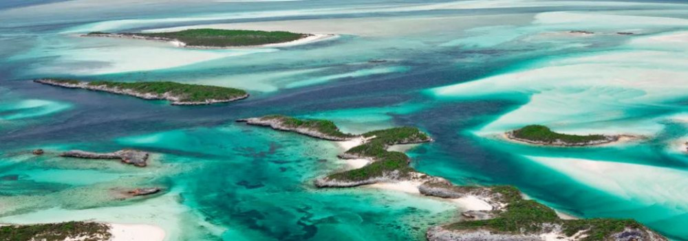
Imagine a tropical sea where the dolomitic peaks of the Keszthely Hills now rise. The landscapes we consider timeless are, in fact, fleeting guests on Earth’s ever-changing stage. How does a shallow tropical sea become Hungarian highlands? Why does dolomite crack? And how does this still influence local farming today? Travel back millions of years into a story written in stone.
The Surface: Only Seemingly Permanent
Mountains, plains, islands, seas, rivers, and lakes may appear permanent within a human lifetime — but from Earth’s perspective, they are only temporary scenes. The rocks that form our planet’s surface are constantly in motion. Like the shattered shell of a boiled egg, tectonic plates drift endlessly atop the semi-fluid mantle beneath them.
Some crash together or sink beneath one another to create towering mountain ranges, while others subside, forming deep trenches or basins that may fill with water. That’s how the dolomite and limestone now forming the Keszthely Hills were once deposited — in the shallow waters of an ancient tropical sea, thousands of kilometers from their present location and long since gone.
The scene would have resembled the crystal-clear shallows of today’s Bahamian paradise.
Volcanoes in the North, a Tropical Sea to the South
While the northern block of the Keszthely Hills is made of relatively young (a few million years old) volcanic rock, the southern section — including Rezi and Cserszegtomaj — is dominated by much older dolomite, formed in those ancient tropical seas. Alongside widespread formations of so-called Main Dolomite, small patches of Rezi Dolomite can also be found — dating back over 200 million years.
The Keszthely Plateau is dissected by a north–south valley system and crisscrossed by micro-tectonic fault lines. Due to the shallow topsoil and varied terrain, more than 70% of the area is forested. Its karst surface experiences year-round water scarcity and has unique ecological features.
The plateau is divided by intermontane basins and bordered by deep tectonic fractures (such as the Hévíz and Ederics faults), making the area seismically sensitive.
Geology and Today’s Land Use
Soils formed on the debris of weathered dolomite provide the natural foundation for land use in the region. Several of our local producers cultivate land along the western edge of the Keszthely Plateau, where farming is defined by the proximity of a highland landscape — a plateau formed of horsts rising 350–440 meters, framed by tectonic fault lines.
51. CseroSajt
Last modification: 2025. November. 26. 11:15
Smoked parenyica, spiced gomolya, sweet whey cream — if you love authentic flavors, you simply must try CseroSajt!

Találati relevancia adatok
Tárolt adatok:
Imagine a tropical sea where the dolomitic peaks of the Keszthely Hills now rise. The landscapes we consider timeless are, in fact, fleeting guests on Earth’s ever-changing stage. How does a shallow tropical sea become Hungarian highlands? Why does dolomite crack? And how does this still influence local farming today? Travel back millions of years into a story written in stone.
The Surface: Only Seemingly Permanent
Mountains, plains, islands, seas, rivers, and lakes may appear permanent within a human lifetime — but from Earth’s perspective, they are only temporary scenes. The rocks that form our planet’s surface are constantly in motion. Like the shattered shell of a boiled egg, tectonic plates drift endlessly atop the semi-fluid mantle beneath them.
Some crash together or sink beneath one another to create towering mountain ranges, while others subside, forming deep trenches or basins that may fill with water. That’s how the dolomite and limestone now forming the Keszthely Hills were once deposited — in the shallow waters of an ancient tropical sea, thousands of kilometers from their present location and long since gone.
The scene would have resembled the crystal-clear shallows of today’s Bahamian paradise.
Volcanoes in the North, a Tropical Sea to the South
While the northern block of the Keszthely Hills is made of relatively young (a few million years old) volcanic rock, the southern section — including Rezi and Cserszegtomaj — is dominated by much older dolomite, formed in those ancient tropical seas. Alongside widespread formations of so-called Main Dolomite, small patches of Rezi Dolomite can also be found — dating back over 200 million years.
The Keszthely Plateau is dissected by a north–south valley system and crisscrossed by micro-tectonic fault lines. Due to the shallow topsoil and varied terrain, more than 70% of the area is forested. Its karst surface experiences year-round water scarcity and has unique ecological features.
The plateau is divided by intermontane basins and bordered by deep tectonic fractures (such as the Hévíz and Ederics faults), making the area seismically sensitive.
Geology and Today’s Land Use
Soils formed on the debris of weathered dolomite provide the natural foundation for land use in the region. Several of our local producers cultivate land along the western edge of the Keszthely Plateau, where farming is defined by the proximity of a highland landscape — a plateau formed of horsts rising 350–440 meters, framed by tectonic fault lines.
52. Visitor Policy Hévíz
Last modification: 2025. November. 12. 13:57
Találati relevancia adatok
Tárolt adatok:
53. Accessibility statement
Last modification: 2026. March. 13. 12:04
Találati relevancia adatok
Tárolt adatok:
54. Crossdest
Last modification: 2025. October. 14. 14:13
Találati relevancia adatok
Tárolt adatok:
55. Everything that is about being active
Last modification: 2022. March. 01. 10:16
Találati relevancia adatok
Tárolt adatok:
Hiking or nordic walking with lookouts and castle ruins
The route of the national Blue Trail passes through the most important sights of Hévíz. The Keszthely hills and the hills of County Zala offer several hiking possibilities, which are not even limited by the seasons. Whether it's sunny or snowy, the trails, nature trails, lookouts and rest areas, maintained by the Bakonyerdő Forestry and located in the Balaton-Uplands National Park, are always accessible. Want to spice up your hikes with a little Nordic walking? Rent Nordic walking poles at the Tourinform Office. There, you can also find some hiking maps. Whether you hike in the Keszthely Hills or at the Kis-Balaton, the scenery will be spectacular. On the top of almost every hill, there is a castle or a lookout tower from where you have a fantastic panorama of the western bay of Lake Balaton.
Running is a way of life
Running is the most popular and healthiest sport in the world. Whether you're a marathon runner, a cross-country runner or simply a fan of running, you can find the routes starting from Hévíz that suit you best. You'll find shorter running trails in the protective forest, but if you want to get away from the town, you can choose from several routes depending on whether you want to run on asphalt or dirt roads and what difference in the level you want to take. There are routes in built environments, but even more in nature, where rest areas are available alongside the hiking trails. Where to start? Our hiking tips can help you to decide.
Segway tours - for anyone over the age of 10
If you think segway is not a sport, try a longer ride and your leg muscles will tell you how much you've used them while standing on the segway. This unique vehicle can be steered based on the movements of the human body and, above all, is totally environmentally friendly. There are guided Segway tours on several routes in Hévíz, but you can even roll to Keszthely for a longer trip.
On two wheels: by bicycle, e-bike
Many people like cycling, and Hévíz offers everything for a longer or shorter bike tour as there are numerous cycle paths in the town and the whole West Balaton region. Not a professional or with a small child? That's not an issue either as most cycle paths are located farther away from heavy traffic and have rest areas and refreshment stops. Take a cycling map, rent an adult or children's bike from us at the Tourinform Office and you're free to explore the best places in the area. If you want to be on the safe side or if you want to go for a cooler means of transport, we can also provide you with a fully charged e-bike or e-roller in the Tourinform Office in Hévíz. And if you rent them for several days, we can even give you a charger, as they can be recharged from the mains in a few hours.
ez HERE!
Adventure in the air
Admiring Lake Hévíz, the western bay of Lake Balaton or Kis-Balaton from a bird's eye view is an unforgettable experience. If you like extreme situations and you like to soar in the air, you can choose from a pleasure flight, a sightseeing tour with a micro lighter, and even more extreme gyrocopter or Hungary's largest hot air balloon. But why should you choose?
Try them all! Balaton Ballooning information, dates and booking HERE!
Fly Miki gyrocopter and micro lighter information and booking HERE!
Adventure parks for children and adults
There can be a huge difference between adventure parks. There is a wide variety of adventure parks near Hévíz to choose from, including indoor and outdoor parks, traditional parks with ropes courses and amusement parks, and even life-size dinosaurs in Rezi. Of course, there are also different levels of difficulty. While some places are suitable for smaller children, others are better for teenagers.
Here are the best adventure parks in the area:
Tavirózsa adventure park
Located between Hévíz and Keszthely, it offers active recreation for the whole family: traditional rope courses, zipline, mini-golf, petanque./ Bobo fun park - Alsópáhok | Indoor adventure park on 3 levels of 3,000 square meters with 30 attractions: climbing walls, free jump, punching bag maze, and a lot more. Great location for team building programmes, class trips, family outings, or even for active indoor sports and energy release. It is recommended for all ages.
Dinosaur and Adventure Park - Rezi
Ropes course, life-size dinosaurs and countless adventure activities with outdoor games only for the whole family.
Rifle shooting, clay pigeon shooting, paintball
An exciting, out-of-the-ordinary programme in a beautiful setting. On open days, the sport shooting range in Gyenesdiás offers the opportunity to try clay pigeon shooting under professional guidance, but you can also shoot pistols and shotguns. For those who prefer a less dangerous form of shooting in a group, the Gyenesdiás paintball field is the ideal choice. Information and advance booking on the Sport Shooting Range's website.
Paintball field information here.
Canoe tours in Hévíz, on Lake Balaton, at Kis-Balaton and on the River Zala
The Hévíz stream is fed by the hot water of Lake Hévíz, so it does not freeze in winter. Uniquely, the 9-kilometre stretch can only be paddled in winter as the stream is protected for its flora and fauna, and can only be paddled when nature is at rest. Canoeing in the winter landscape on the steaming stream in the snowfall is a truly fabulous experience for families or groups of friends. For those who would prefer to do it in the summer, we recommend the tours organised by Kis-Balaton Visitor Centre, the Balaton sunset canoe trip or the all-day River Zala trip. Information about the winter tours of Hévíz is available at the Tourinform Office
For the tours organised by Kis-Balaton, please contact the Balaton-Uplands National Park.
Sports on the lake - sailing, windsurfing, SUP, canoeing, paddle boat, kayaking
If you are fond of water sports, you can sail, windsurf or SUP on one of the beaches of Keszthely, only 15 minutes from Hévíz. Most beaches have paddle boats or other paddling vehicles for hire. There are guided canoe trips on Lake Balaton and Kis-Balaton, but if you'd rather just enjoy being on the water, take one of the cruise boats from the pier of Keszthely. Are you looking for something more extreme in the water? For years, there has been a very popular water-skiing track in Vonyarcvashegy, and in the spring of 2021, the floating extreme adventure park was completed on the Municipal Beach in Keszthely. Lake Balaton can also be interesting if you arrive in the depths of winter: if it freezes over you can skate, chair ski or ice sail.
Aqua aerobics and Aqua bike
Moving in the water reduces the risk of injury thanks to the resistance of the water, and at the same time, it develops muscular strength, endurance and coordination. Aqua aerobics with Aniko Papp on Friday afternoons at Hotel Spa Hévíz. Aquabike at Bonvital Wellness & Gastro Hotel - available not only for hotel guests.
BÁZIS - spin racing, close combat, trx, yoga...
In the Bázis fitness room on Dombföldi street in Hévíz, you can choose from a variety of sports such as spin racing, close combat, trx, army pt. In the latter training session, you can perform physical endurance and mental strength exercises, using kick and strike pads and strengthening equipment, as well as simple clocked exercises. However, there are several fitness rooms in Hévíz, such as in the Hévíz Lake Baths and the Kolping Hotel Spa & Family Resort, where you can also go to train with a day ticket or a pass. Yoga classes are offered not only in the Bázis but also in several other places all year round.
Tai-Chi and Chi-kung
Perfect relaxation technique and ideal form of exercise for greater flexibility and mobility, as well as an excellent way of prevention. The practices are available in some hotels and the Hotel Spa Hévíz offers them even to non-hotel guests.
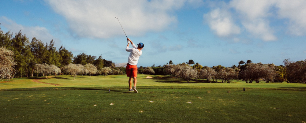
Golf for ladies, gentlemen and everyone
Zala Springs Golf Resort is a world-class golf course designed by the world-famous course designer Robert Trent Jones Jr. and is located only 10 km from Hévíz. The 18-hole championship golf course is suitable for both beginners and advanced players to learn or improve their golf skills with the help of professional instructors, in individual and group lessons.
Go-kart for the lovers of speed
The Blokk Go-kart track is located in the neighbourhood of the Tavirózsa Adventure Park on the outskirts of Hévíz. There are two tracks in fact because besides professional racers there is also a smaller, beginners' track, where beginners and younger age groups can try themselves.
Horse riding
Club Dobogómajor offers well-trained horses, indoor and outdoor riding arenas for beginners, advanced and experienced riders alike. Both beginners and advanced riders have the opportunity for individual and group riding lessons. And for the youngest riders, pony rides are available from 3 to 7 years of age. Those who have not tried riding before can take part in riding lessons, and those who are already experienced in riding can book a one-day cross-country ride at the Lovaspanzió in Hévíz.
Tennis
The Novák Tennis Club in Club Dobogómajor offers four clay courts and an indoor sports hall for the fans of tennis or those who want to get acquainted with this popular ball game now. There are two clay courts in Keszthely, one in Ady Street and the other on the shore of Lake Balaton.
Squash, bowling, billiards
Whether the weather is good or bad, whether you are alone or in a large group, you can actively spend a whole day in the House of Sports in Gyenesdiás. In the basement, there are two squash courts and a two-lane bowling alley. The upstairs restaurant has a billiard table and a variety of board games for your entertainment.
You have expected good weather but it’s raining cats and dogs? Read our tips to see where to go!
Bobo Fun Park
Hungary's largest indoor adventure park. 30 attractions on 3 floors on 3,000 square metres await you in Alsópáhok. Climbing walls, free jump, punching bag maze, trampolines, cave exploration game and much more. An excellent programme for team building, class outings or family trips. The park has a course for all ages as the challenges vary by age.
Aqua Aerobics and Aqua bike
Moving in the water reduces the risk of injury thanks to the resistance of the water, and at the same time, it develops muscular strength, aerobic endurance and coordination. Aqua Aerobics with Aniko Papp on Friday afternoons at the Hotel Spa Hévíz... Aqua bike at Bonvital Wellness & Gastro Hotel - available not only for hotel guests.
BÁZIS Gym – spin racing, trx ...
In the Bázis Gym on Dombföldi street in Hévíz, you can choose from a variety of sports such as spin racing, close combat, trx, army pt. In the latter training session, you can perform physical endurance and mental strength exercises, using kick and strike pads and strengthening equipment, as well as simple clocked exercises. You can also use fitness rooms in several other locations in Hévíz, for example in the Hévíz Lake Baths or in the Kolping Hotel Spa & Family Resort, where you can also buy a day pass.
Indoor yoga
You can also join yoga classes in the Bázis Gym and the Hotel Spa Hévíz. Information and timetables are available at the venues.
Horse riding
Club Dobogómajor offers well-trained horses, indoor and outdoor riding arenas for beginners, advanced and experienced riders alike. Individual and group riding lessons are available both for beginners and advanced riders, and the youngest (aged 3-7) can take a pony ride.
Tennis
The Novák Tennis Club in Club Dobogómajor has four clay courts and, if the weather is not favourable, an indoor sports hall for tennis lovers or those who want to get acquainted with this popular ball game.
Squash, bowling, billiards
Whether the weather is good or bad, whether you are alone or in a large group, you can actively spend a whole day in the House of Sports in Gyenesdiás. In the basement, there are two squash courts and a two-lane bowling alley. The upstairs restaurant has a billiard table and a variety of board games for your entertainment. The No.1 Billiard Saloon in Keszthely awaits you with billiards tables, snooker tables and darts boards.
Active programmes on the beaches, in the marinas
On several beaches of Lake Balaton you can rent canoes, kayaks, SUP and of course paddle boats. If you want to experience something more challenging, you can also try the water adventure park on the Municipal Beach of Keszthely or the water skiing track on the beach of Vonyarcvashegy. Going on a pleasure cruise is less active but also can be great fun. There are not only scheduled boat services from the Keszthely pier but also themed excursion boats. And if you want to drive a boat yourself, you can hire a small motorboat in the bay.
Kis-Balaton Paddling tours
The Balaton-Uplands National Park organises canoe trips to Diás Island on the Gyöngyös stream during the summer. The group can visit the István Fekete Memorial and Uncle Matula’s Hut, which evokes the atmosphere of the famous Hungarian novel Tüskevár. Advance booking is required for the tours. Guided tours around the Kányavár Island on Kis-Balaton are also available.
Paddling on the River Zala
Paddling on the River Zala for 12 km from Zalaapáti to Zalavár, an easy all-day programme for everyone
Canoeing in winter on the steaming Hévíz Stream
Those who are attracted to extreme conditions can try paddling on the steaming Hévíz Stream from November to March. As protected plants bloom in the stream in the summer and several water birds breed in the reeds along the banks, paddling on the stream is only allowed in the winter with a tour guide. However, it's a fantastic experience, especially if it is snowing. You can have more details about tours at the Hévíz Tourinform Office during the winter season.
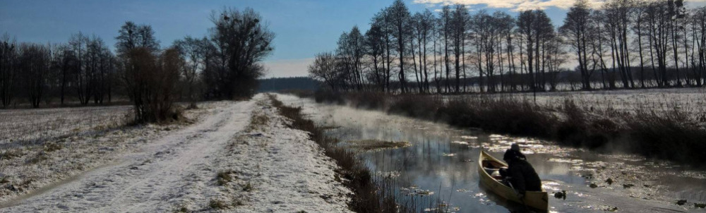
Canoeing on the Hévíz stream
The most popular winter sport in Hévíz is canoeing: The Hévíz stream is fed by the hot water of Lake Hévíz, so it does not freeze in the winter. Uniquely, the 9-kilometre stretch can only be paddled in winter, as the stream is protected for its flora and fauna, and can only be paddled when nature is at rest. Canoeing in the winter landscape on the steaming stream in the snowfall is a truly fabulous experience for families or groups of friends. Dates, prices, conditions of participation can be found here.
The largest indoor adventure park in the country - Bobo Fun Park
Indoor adventure park with 30 attractions on 3 levels and 3,000 square metres. Climbing walls, free jump, punching bag maze and much more. An excellent programme for team building, class outings or family trips for kids and adults alike. There are some rules for using the adventure park, click here for information, prices, opening hours. / Running trails and stretching stations in the protective forest / Some people are not deterred by the winter cold from running outdoors. For them, we recommend the wind-protected running trails of the protective forest since they can choose from trails with several distances and several levels of difficulty. Running here is safe and enjoyable even in winter.
You can also shoot in winter
Rifle shooting is an exciting and unusual programme. In the modern shooting range, located in a beautiful natural setting, amateurs can try clay pigeon shooting, pistol and shotgun shooting under professional guidance on open days. For those who prefer to shoot with less dangerous weapons and in a team, the Gyenesdiás paintball field is the ideal place.
BÁZIS Gym – spin racing, trx ...
In the Bázis Gym on Dombföldi street in Hévíz, you can choose from a variety of sports such as spin racing, close combat, trx, army pt. In the latter training session, you can perform physical endurance and mental strength exercises, using kick and strike pads and strengthening equipment, as well as simple clocked exercises. You can also use fitness rooms in several other locations in Hévíz, for example in the Hévíz Lake Baths or in the Kolping Hotel Spa & Family Resort, where you can also buy a day pass.
Indoor yoga
You can also join yoga classes in the Bázis Gym and the Hotel Spa Hévíz. Information and timetables at the venues
Riding
Club Dobogómajor offers well-trained horses, an indoor riding arena and, for the more adventurous, outdoor courses for beginners, advanced and experienced riders alike. Individual and group riding lessons are available both for beginners and advanced riders, and the youngest children (aged 3-7) can also ride ponies. Those who have never ridden a horse before can take part in riding lessons, and those who are already experienced in riding can book a one-day cross-country ride at the Hévíz Lovaspanzió.
Tennis
The Novák Tennis Club in Club Dobogómajor has four clay courts and, if the weather is not favourable, an indoor sports hall for tennis lovers or those who want to get acquainted with this popular ball game.
Squash, bowling, billiards
Whether the weather is good or bad, whether you are alone or in a large group, you can actively spend a whole day in the House of Sports in Gyenesdiás. In the basement, there are two squash courts and a two-lane bowling alley. The upstairs restaurant has a billiard table and a variety of board games for your entertainment. The No.1 Billiard Saloon in Keszthely awaits you with billiards tables, snooker tables and darts boards.
Ice skating
In the winter months, when Lake Balaton freezes over, you can skate, chair ski or ice sail. At the Energia Square in Keszthely, children can practise their favourite Balaton sport, ice skating, every day after dark during the winter months, even if Lake Balaton is not frozen over.
56. Picnic Hévíz
Last modification: 2025. November. 26. 13:40
Találati relevancia adatok
Tárolt adatok:
Did you know the Zala River once flowed into the Drava and only later “found” Lake Balaton?
The history of western Hungary’s water systems is not just a fascinating geological puzzle — it reads like an epic of Earth history: riverbeds shift, rivers “consume” one another, and even Lake Balaton doesn’t enter the scene until the final chapter. Discover how nature reshaped this landscape stroke by stroke — and how the Zala became Balaton’s most vital source of water.
The Quaternary Period and the Power of Landscape Formation
What sets the Quaternary Period (2.58 million years ago to the present) apart from earlier geological epochs is that the surface-shaping processes of this time — and the landforms they produced — continue to define our geographic environment today.
Pleistocene Changes: Riverbed Migrations and Terraces
One of the most pivotal surface processes during the Pleistocene (2.58 to 0.01 million years ago) was the migration of riverbeds and the formation of terraces and alluvial fans. These changes were closely tied to the slow retreat of the Pannonian Lake, which once filled much of the Carpathian Basin (see also: The Legacy of the Ancient Pannonian Lake).
The Ancient Danube Moves West
The early Danube initially flowed westward across what is now western Hungary, draining into the retreating Pannonian Lake. This westward course likely remained until the early Pleistocene.
A River’s Great Turning Point
The most dramatic hydrological change in the Carpathian Basin occurred between the Pliocene and Pleistocene: the formation of the Danube’s Visegrád Gorge (today’s Danube Bend), which diverted the river toward the center of the country and what is now the Pest Plain.
This shift profoundly affected all its former western tributaries — including the Zala.
The Story of the Zala: Migration and Capture
The river system of Central Transdanubia evolved in surprising ways, and the Zala’s journey is one of its most remarkable chapters. The Rába River already flowed northeastward toward the Little Hungarian Plain. The ancient Marcal, running northward, flowed into the Rába — and into it, in turn, flowed the ancient Zala.
But nature redrew the map — using the Zala as its brush. A now-vanished river flowing from north to south (its remnants visible today between Zalaszentgrót and Zalavár) cut into the landscape through a process called headward erosion — where rivers erode backward into the terrain, much like a hot knife slicing through butter. Eventually, it cut into the ancient Zala’s valley and “captured” the river, diverting it into its own course.
A New Path — and the Birth of Lake Balaton
From then on, the Zala made a sharp turn south at Türje and — with no Lake Balaton yet in existence — initially emptied into the Drava. Later, as the depression that would one day become Lake Balaton deepened, the Zala was gradually drawn toward it.
Lake Balaton, as a continuous body of water, is only about 5,000 years old — but for millions of years before, the Zala had already been on a winding journey that ultimately made it Balaton’s primary source of water, and the most life-giving river in the region today.
The Life-Giving Winds of the Ice Age: How Loess Shaped the Land
Did you know that Transdanubia’s rich, golden soils are actually a gift from the winds of the Ice Age? Loess isn’t just a dry geological term — it’s an ancient natural recipe that gave rise to some of the most fertile soils in the Carpathian Basin. Where vineyards grow today and birds nest in loess cliffs, strong winds once carried yellow dust across the landscape — for thousands of years. Learn how this unique sediment shaped the land and why loess is still essential for sustainable farming today.
What Is Loess and How Did It Form?
The term loess comes from the German word lose, meaning "loose." Loess is a fine-grained, yellowish sediment that was deposited during the Pleistocene epoch (2.58–0.01 million years ago), particularly during glacial periods. It formed in periglacial environments south of the great Scandinavian ice sheet — cold, dry landscapes with little or no vegetation.
The dust was carried by strong Ice Age winds from floodplains and barren steppes, and slowly accumulated over tens of thousands of years. Eventually, calcium carbonate cemented these layers into loess, which developed characteristic vertical fissures.
It’s important to note that the Pleistocene wasn't a single “Ice Age,” but a period that included alternating cold and warm phases — some even warmer than today.
Loess and the Landscape
Loess gave the Carpathian Basin — especially Transdanubia — its distinct terrain.
Steep loess cliffs (sometimes up to 10 meters high), caves that provide nesting sites for bee-eaters and sand martins, centuries-old sunken roads carved into hillsides, and exposed root systems are all part of the landscape’s geological legacy.
Together, they define the unique character of this region — shaped by time, wind, and stone.
Fertility and Water Retention
Loess-rich areas have produced some of the most fertile soils in the region. Many local producers farm on land that sits atop loess. This creates an excellent foundation for agriculture — not just because of the high humus content, but also because loess has outstanding water-holding capacity. Its vertical pores allow moisture to penetrate deeply and remain in the soil, even during dry periods.
A Modern Echo — Dust from the Sahara
Interestingly, the fine Saharan dust that now reaches Central Europe more frequently can be seen as a modern counterpart to loess-forming material. It’s a reminder that the powerful natural forces that shaped the land long ago are still at work today — just on a different scale.
Imagine a vast body of water — over 1,000 meters deep and more than 400 times the size of Lake Balaton — once rippling across this land. The story of the Pannonian Lake is not just a fascinating chapter of geological history, but a legacy that continues to shape the region: it left behind mineral resources, fertile soils, and even inspired legends. Discover how an ancient lake transformed Transdanubia — and why its impact is still felt today.
An Inland Sea for Millions of Years
At its greatest extent, the Pannonian Lake covered an enormous area, far surpassing the size of today’s Balaton. For millions of years (approximately 12 to 8.5 million years ago), it dominated the region. As surrounding mountain ranges gradually rose, the lake became cut off from the world’s oceans. Its water slowly turned fresh, and its basin began to fill with sediments. Because of its isolation, the lake developed a unique ecosystem with many endemic species.
The Lake Didn’t Appear Overnight
The Pannonian Lake didn’t simply “appear” in the Carpathian Basin. Its formation was the result of millions of years of tectonic activity and shifting climate. It emerged as an independent, enclosed body of water — no longer connected to the open seas.
Deep Waters, Varied Shores
In some areas, the lake reached depths of over 1,000 meters. Elsewhere, shallower zones supported lagoons, river deltas, and small, isolated lakes. During high water periods, rocky shorelines formed along the mountain fringes — traces of which can still be found today in the Keszthely Hills and the Mecsek Mountains.
The Lake’s Retreat — and Sediment Legacy
Despite its size, the lake was eventually filled in by immense volumes of sediment, carried mainly by rivers flowing from the Alps and the Carpathians. Over the course of 6.5 million years, it gradually disappeared from the landscape.
What did it leave behind?
Its sediments — composed mostly of sand, clay, and fine silt — became the so-called “Pannonian formations,” which today hold key mineral resources (such as petroleum) and aquifers. These formations define much of the surface geology of Transdanubia, including the Zala Hills.
Fertile soils later formed on the laminated silty and clay-rich deposits of the Somló Formation. Even the legendary “Tihany goat’s hoof” fossils — actually worn shell fragments of the Congeria ungulacaprae mollusk — can still be found embedded in these ancient layers.
The Final Lakes and a Gradual Goodbye
Because most of the sediment entered from the northwest, north, and northeast, the lake slowly retreated toward the south and southeast — as if it were “withdrawing” from what is now Hungary.
Small remnant lakes persisted for much longer in areas of present-day Slavonia (Croatia) and northern Serbia, but due to their different scale, character, and fauna, they are not considered true successors of the ancient Pannonian Lake.
About 10,000 years ago, rapid climate warming triggered a cascade of natural responses: torrential floods, landslides, and intense rock weathering. The landscape we walk on today was not shaped over mere centuries, but by the dramatic forces of climate and water, working together. Did you know that the Zala Valley floor is made up of sediments deposited by a kind of "river of time"? Discover how the Earth’s surface became one of the most sensitive indicators of climate change.
Climate Change: Not Just a Modern Phenomenon
We often associate climate change with contemporary issues, but Earth’s climate has shifted many times throughout its history — sometimes quite rapidly. Within large-scale climatic cycles, alternating periods of warming and cooling have long been part of the planet’s natural rhythm.
When Climate Changes, Everything Reacts
A change in climate sets off a chain reaction of environmental processes. It’s not just animals and plants that respond — so does the landscape itself.
Around 10,000 years ago, as the climate warmed significantly, rainfall became more intense.
More rain meant more erosion: stormwater began washing away sediment from hills and valleys into riverbeds. The rivers, now carrying more water and more sediment, flooded more often and spread these materials across the landscape.
Shaping the Terrain
This had a major impact on topography: the land surface became more fragmented and dynamic. Warming temperatures also sped up chemical and physical weathering, breaking down bedrock and helping fertile soil layers to develop.
In short, natural geological processes that had long been underway suddenly accelerated — and reshaped the surface of the land.
Young Sediments at the Base of the Slopes
Today, in many areas of the region, the lower slopes and valley edges are coated with sediment — debris washed down from higher ground, largely within the last 10,000–20,000 years. In the Zala Valley, for instance, these deposits have spread so far that they now reach the center of the valley floor.
The original bedrock source of these sediments varies: in Zala, it’s typically Pannonian sand (Somló Formation), while in the Keszthely Hills, marine-origin carbonates dominate — mostly dolomite, with some limestone. These sediments now appear as fine gravel, pebbles, or coarse sand, quietly recording the environmental changes of the recent past.
Imagine a tropical sea where the dolomitic peaks of the Keszthely Hills now rise. The landscapes we consider timeless are, in fact, fleeting guests on Earth’s ever-changing stage. How does a shallow tropical sea become Hungarian highlands? Why does dolomite crack? And how does this still influence local farming today? Travel back millions of years into a story written in stone.
The Surface: Only Seemingly Permanent
Mountains, plains, islands, seas, rivers, and lakes may appear permanent within a human lifetime — but from Earth’s perspective, they are only temporary scenes. The rocks that form our planet’s surface are constantly in motion. Like the shattered shell of a boiled egg, tectonic plates drift endlessly atop the semi-fluid mantle beneath them.
Some crash together or sink beneath one another to create towering mountain ranges, while others subside, forming deep trenches or basins that may fill with water. That’s how the dolomite and limestone now forming the Keszthely Hills were once deposited — in the shallow waters of an ancient tropical sea, thousands of kilometers from their present location and long since gone.
The scene would have resembled the crystal-clear shallows of today’s Bahamian paradise.
Volcanoes in the North, a Tropical Sea to the South
While the northern block of the Keszthely Hills is made of relatively young (a few million years old) volcanic rock, the southern section — including Rezi and Cserszegtomaj — is dominated by much older dolomite, formed in those ancient tropical seas. Alongside widespread formations of so-called Main Dolomite, small patches of Rezi Dolomite can also be found — dating back over 200 million years.
The Keszthely Plateau is dissected by a north–south valley system and crisscrossed by micro-tectonic fault lines. Due to the shallow topsoil and varied terrain, more than 70% of the area is forested. Its karst surface experiences year-round water scarcity and has unique ecological features.
The plateau is divided by intermontane basins and bordered by deep tectonic fractures (such as the Hévíz and Ederics faults), making the area seismically sensitive.
Geology and Today’s Land Use
Soils formed on the debris of weathered dolomite provide the natural foundation for land use in the region. Several of our local producers cultivate land along the western edge of the Keszthely Plateau, where farming is defined by the proximity of a highland landscape — a plateau formed of horsts rising 350–440 meters, framed by tectonic fault lines.