1,000 steps outdoors - Top hiking tips for running, walking, jogging...
Four easy hiking routes in Hévíz
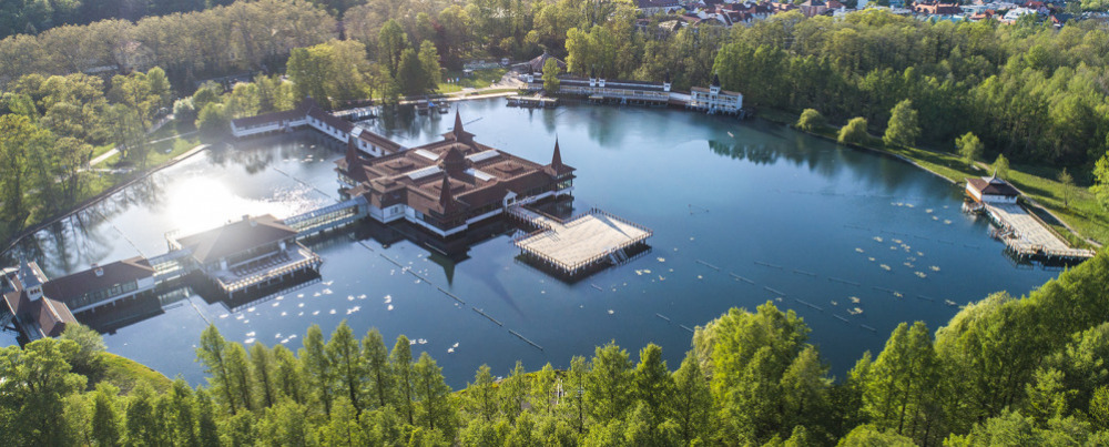
The 60-hectare Lake Hévíz Nature Reserve, the eastern and western protective forests offer a pleasant forest walk. The western park forest (8.8 ha) has a hilly landscape typical of County Zala. The altitude ranges from 115 m to 155 m above sea level. A few centuries ago it was connected with the forest of Egregy. The northern and eastern protective forests cover a total area of 23.1 ha. The flat, semi-wet area here is an integral part of the Nagyberek - Kis-Balaton - Tapolca marsh. In some areas, the peat layer is 6-8 m thick. It takes 30-40 minutes to walk around Lake Hévíz. The impressive 200-year-old plane trees and turn-of-the-century buildings of the Schulhof Promenade, the newly developed Festetics Promenade and the eastern protective forest with its bald cypresses make for a pleasant walk. The paved road offers a nice walk even in rainy weather and in the evenings. Distance: 1.5 km, Accessible, Family-friendly, Catering facilities on the way
The name ‘Berki’ refers to the Hungarian word ‘berek’, which means low-lying, marshy, densely vegetated area. In the old days, the world of the marshland was known only to the local inhabitants; strangers could easily get lost in the marshy, reedy area. Today, thanks to the drainage work of the Festetics family, Lake Hévíz and the stream are easily accessible to everyone. The flora and fauna of the marshland is an extremely rare and valuable natural treasure not only in Hungary but also in Europe. In the warm water, the Indian red water-lily (Nympaea rubra var. loniflora) blooms almost all year round in Lake Hévíz. This plant was introduced by Sándor Lovassy, a teacher at the Keszthely Academy of Economics, between 1898 and 1906. Insectivorous plants, such as the greater bladderwort (Utricularia Vulgaris), which sucks in microscopic animals with the help of tiny bladders, also live here. To help you find your way around, a brochure created by the Hévíz Association for the Protection, Development and Culture of Hévíz and the Keszthely Environmental Protection Association can be downloaded by clicking on the link. vezetofuzet.pdf Distance: 5 km (there and back), No restaurant along the way, dog-friendly, family-friendly
Arriving in Hévíz from the east, many people notice the multi-storey wooden lookout tower, which is interesting not only for its building but also for its history. Jenő Horváth, a horticulturist and botanist, who was 90 years old at the time, built the lookout for his beloved wife Margit in the early 2000s. He wanted his wife to be able to see Lake Balaton, if not from a closer distance, at least from the top of the lookout tower. For his wife's sake, he had a special lift installed in the lookout tower. The lookout is located on private land and used to be open to the public, but since 2015 it is no longer accessible. Still, many people like to walk to the 31 m high lookout, which can be found 2.5 km away from Hévíz. To get to Cserszegtomaj, you have to follow the yellow sign and continue the hike. 700 m away from the Margaret Lookout, you will find the Cserszegtomaj well cave, which is of thermal water origin and can be visited with the permission of the Balaton-Uplands National Park Directorate. Distance: 6 km (back and forth), no restaurant, dog-friendly, accessible
The National Blue Trail passes through the most beautiful parts of Hévíz. It passes by Lake Hévíz, the Church of the Holy Spirit, the Church of the Heart of Jesus, the Egyregy Museum, the row of wine cellars in Egregy and the Árpád-era church. After leaving the town of Hévíz, the trail also passes the Jewish cemetery in Karmacs, which was renovated in 2012. Opposite the cemetery, at the bottom of the Rezi vineyard, you can see the Gyöngyösi Betyárcsárda (Highwaymen’s Inn of Gyöngyös), which can be reached after 1.5 km on the blue sign. The ancient walls tell many stories of the highwaymen, including the one where Jóska Sobri danced with his lover Rozi Répa. According to another story, Illés Vak and Pista Kökes were ambushed and shot by the Pandurs in the vineyard near the inn, and their graves are probably located under the two wooden crosses next to the inn. Distance: 9 km - back and forth, Restaurants can be found on the row of wine cellars in Egregy and of course the Highwaymen’s Inn, family-friendly, dog-friendly
Family-friendly hikes around Hévíz
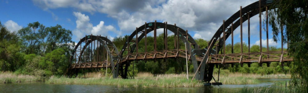
Within a half an hour's drive from Hévíz, you can easily reach the Kis-Balaton, a unique wetland habitat in the Balaton-Uplands National Park. The 1.6 km Great Crested Grebe Nature Trail on Kányavári Island features fifteen panels showing the typical birds of Lake Kis-Balaton. In many cases, the great egret (Egretta alba) and the greylag goose (Anser anser), the squacco heron (Ardeola ralloides), the little egret (Egretta garzetta), the spoonbill (Platalea leucorodia) or the Eurasian bittern (Botaurus stellaris) can be observed with the naked eye or binoculars. You can fish on the island with a licence, but there is also a sports field and a lookout tower for active recreation. Distance of the hiking trail: 1.6 km, family-friendly, dog-friendly, barbecue facility and snack-bar
Only a half-hour drive from Hévíz, starting from the basalt quarry in Vindornyaszőlős, which is still in operation today, you can discover the unique "construction" of nature - the basalt street. A bird on a white background next to the S tourist sign marks the trail. The unique natural formation on the Kovácsi Hill is one of the seven wonders of Zala County, a protected area of the Balaton-Uplands National Park. As a result of erosion and land-slide, the strange stone formations, consisting of cracked basalt columns that have been split off the rim, present a chaotic world. As the wind blew the sand from beneath the basalt rocks, the huge blocks of volcanic rock tilted along the vertical cracks. Caves and interesting morphological formations of various cavities are hidden between the 5-15 m high columns. The trail is named after the late Ferenc Buruczki, a great naturalist who died young. The ten information panels describe the geological, botanical and zoological values of the area and also show how to track four-legged animals. Distance: 4 km (back and forth), No catering facilities, family-friendly, dog-friendly
According to the research of the famous Keszthely scientist and museologist Dr Béla Darnay-Dornyai, the first spring of Hévíz broke out on Meleg Hill near the Rezi Castle about 2 million years ago. Meleg Hill (‘Hot Hill’) got its name from the fact that in winter when snow covered the landscape, the snow always melted near the volcanic thermal spring. The second place of uprush was the Cserszegtomaj well cave, and then, about a million years ago, sulphurous thermal water appeared on the Biked Hill near Hévíz, and later on the Dobogó Hill. Today's Lake Hévíz was formed at the same time as Lake Balaton by crustal movements 20-22 thousand years ago. The hiking trail of the Balaton-Uplands National Park leads along the most spectacular karstic formations created by the thermal waters. The starting point of the trail is Kőhát Street in the centre of Cserszegtomaj. From here, following the S+ sign to the Csóka-kő, hikers can see a series of holes and small caves, which have been carved out by the thermal waters. The Csókakő (Jackdaw stone) got its name because its hard-to-access cavities were used by jackdaws. Worth a visit: Kígyóvári-szikla, Függő-kő. Passing the forester's house at Csorna-kút, the K+ sign on the left takes you to Rezi. If you don't want to go that far, turn back from the forester's house and walk 3 km along the dirt road of the Csornakúti Valley, which leads back to Cserszegtomaj. Distance: 10 km, No catering facilities, family-friendly, dog-friendly
The Csodabogyós cave in Balatonederics can be reached after half an hour's drive from Hévíz. The cave is named after the prickly knee-holly, a red-berry evergreen shrub with a Mediterranean distribution, which is widespread on the sunny side of the Keszthely Hills. The cave can only be visited with a guide from the Balaton-Uplands National Park but it is necessary to book your tour in advance. During the guided section of about an hour, you can expect some crawling and climbing. The National Park provides a helmet and a high-intensity headlamp, as well as a caving oversuit. The cave, rich in dripstones, is one of the largest caves in the Bakony region. After visiting the cave, it is possible to continue the hike without a guide towards the Jukucs László cave and the Sipos mouth on the green sign, then you can turn back to the starting point (Balatonederics) on the red and green sign. Guided tour, Distance covered: 5 km, Duration: 3 hours +1,5 hours cave visit, Difference in level: 300 m, Catering facilities: none, Child-friendly: 10+ If you want to do more caving, you can choose between two more extreme tours under the management of A.G. Explorer Turisztikai Kft., which is a contracted partner of the Balaton-Uplands National Park.
The Nagymező in Gyenesdiás, located only a 15-minute drive from Hévíz, is a popular picnic spot in the area. Although you can also drive up to the Nagymező, it is worth taking the yellow-marked road from the centre of Gyenesdiás to the Nagymező, from where you can follow the K ∆ sign for a few minutes to the Festetics lookout, and from the forest gymnastics field on the Nagymező the S+ and S∆ signs will take you to the Berzsenyi lookout, where you can see the whole western end of Lake Balaton in a 360-degree panorama. The yellow sign leads through the Tüskés láp (Spiky bog) to the legendary Vadlánlik. According to the local legend, wild girls wandered barefoot in the forest, their only clothing was a shawl tied around their waists, their bosoms were covered by their long hair, and their song, like the sirens', lured fishermen to the Szerelem hill (Love hill) in Balatongyörök. The Vadlánlik cave in Gyenesdiás, like the other cavities in the Keszthely Hills, are openings formed by wind erosion. The locals used the Vadlánlik cave as a secret distillery at the end of the 19th century. Route: Tourinform office, Gyenesdiás - Jókai Street - Quarry (S)- Nagymező - Festetics lookout (K∆) - Forest gymnastics trail - Pető Hill, Berzsenyi Lookout - Tüskés láp (Spiky bog) - Vadlánlik cave - Dolomite nature trail - Light Cross - Statue of Mary, Kesellő - Bem Street - Darnay Street - Jókai Street - Tourinform office, Gyenesdiás Distance: 11 km, Walking time: 3.5 hours, Difference in level: 410 m, Family-friendly, Dog friendly
Even the Romans were fascinated by the area around the Szépkilátó (Lookout point). A villa was built under the lookout point and the spring, now known as the Roman well, provided running water. During the lookout hike, after overcoming considerable differences in height, you can visit the Mátyás Bél and Batsányi lookout towers to admire, from different perspectives, the buttes surrounding this part of Lake Balaton. After the built-up Szépkilátó car park, you can enjoy a wonderful panorama from different angles on a hike with considerable differences in level. Szép-kilátó car park-(P)-Garga-nyereg-(S∆)-Bél Mátyás lookout tower -(S∆)-Pele nature trail-(S)-(P+)-(P)-(P)-Bise-kő tető-(P∆)-Batsányi lookout tower -(P∆)-Szépkilátó Distance: 7 km, Duration: 4-5 hours, Difference in level: 250 m, Catering facilities: at the Szépkilátó, Child-friendly, dog-friendly
Castle tours
The ruins of the Rezi Castle, built at the end of the 13th century, stand on the dolomite cliffs of Meleg Hill. The castle was probably built between 1292 and 1307 by Apor and Lukács of the Pécz clan, who owned the village, and from the 14th century, it was the property of the Gersei-Pethő family. However, by 1571, the financial position of the Pethő family deteriorated considerably. The castle, in bad condition and poorly guarded, was demolished to prevent it from falling into Turkish hands. A charter from 1592 mentions the ruined castle of Rezi. The archaeological excavation of the castle was started in 2000 by the Directorate of County Zala Museums. The Rezi Castle can be reached on foot on the national Blue Trail or by following the blue sign marking the castle from Rezi. In 2014, the Rezi Castle Nature Trail was inaugurated. It starts from the wine press in the village on the national Blue Trail and describes the local fauna and avifauna, the tree species and the geology of the forest on 11 information panels in different languages. You can follow the panels up to the Rezi Castle. Distance: 6 km (back and forth). No catering facilities, child-friendly, dog-friendly
Tátika Castle, a medieval castle ruin, is located on the 413-metre high basalt hill of the Keszthely Hills. There used to be two castles. The Tátika Hill was named after its first owners, the Tátika clan. In 1248, during the Tatar invasion, King Béla IV of the House of Árpád confiscated the Lower Tatika Castle from the Tátika clan and gave it to Bishop Zlaudus. The bishop, learning from the experience of the Tatar invasion, did not consider Lower Tatika Castle secure enough, so he had a new, larger stone castle built on the top of the castle hill. Later the castle became the property of the Gersei Pethő family. After the Battle of Mohács in 1526 and due to the Turkish expansion, the noble families, Pauline monasteries and Franciscans of Keszthely deposited their valuables and treasures in Tátika Castle, which are said to have been worth over 100,000 golden forints. In 1538, the Bishop of Veszprém besieged the castle and simply stole the valuables found there. The castle then fell into disrepair, and in 1589, it was stormed, seized, looted and burnt down by a marauding Turkish troop. Archaeological excavations and restoration work were carried out in the 2000s, so tourists can now tour the preserved parts of the medieval castle ruins. After Zalaszántó, heading towards Sümeg, it is easy to join the National Blue Trail, which takes you straight up to the ruins of the Tátika castle. The trail climbs steeply, but those who climb the 413 m high former volcano can enjoy a wonderful panorama. Distance: 5 km (back and forth) No catering facilities, family-friendly, dog-friendly
Downloadable Keszthely Hills hiking map
Downloadable regional hiking map